
![]()
![ΝΟΤΙΑ ΠΙΝΔΟΣ, ΤΖΟΥΜΕΡΚΑ - ΠΕΡΙΣΤΕΡΙ - ΚΟΖΙΑΚΑΣ - ΑΥΓΟ [3.2 - 4.2]](https://www.klaoudatos-skishop.gr/wp-content/uploads/2022/02/3.2-4.2-945x1811w-150x150.jpg "ΝΟΤΙΑ ΠΙΝΔΟΣ, ΤΖΟΥΜΕΡΚΑ - ΠΕΡΙΣΤΕΡΙ - ΚΟΖΙΑΚΑΣ - ΑΥΓΟ [3.2 - 4.2]")
![ΝΟΤΙΑ ΠΙΝΔΟΣ, ΤΖΟΥΜΕΡΚΑ - ΠΕΡΙΣΤΕΡΙ - ΚΟΖΙΑΚΑΣ - ΑΥΓΟ [3.2 - 4.2]](https://www.klaoudatos-skishop.gr/wp-content/uploads/2019/11/notia_pindos-945x1811-1-450x450-1-150x150.jpg "ΝΟΤΙΑ ΠΙΝΔΟΣ, ΤΖΟΥΜΕΡΚΑ - ΠΕΡΙΣΤΕΡΙ - ΚΟΖΙΑΚΑΣ - ΑΥΓΟ [3.2 - 4.2]")
![ΝΟΤΙΑ ΠΙΝΔΟΣ, ΤΖΟΥΜΕΡΚΑ - ΠΕΡΙΣΤΕΡΙ - ΚΟΖΙΑΚΑΣ - ΑΥΓΟ [3.2 - 4.2]](https://www.klaoudatos-skishop.gr/wp-content/uploads/2019/11/Tzoumerka2019-945x1811w-150x150.jpg "ΝΟΤΙΑ ΠΙΝΔΟΣ, ΤΖΟΥΜΕΡΚΑ - ΠΕΡΙΣΤΕΡΙ - ΚΟΖΙΑΚΑΣ - ΑΥΓΟ [3.2 - 4.2]")
![ΝΟΤΙΑ ΠΙΝΔΟΣ, ΤΖΟΥΜΕΡΚΑ - ΠΕΡΙΣΤΕΡΙ - ΚΟΖΙΑΚΑΣ - ΑΥΓΟ [3.2 - 4.2]](https://www.klaoudatos-skishop.gr/wp-content/uploads/2019/11/Koziakas2019-945x1811w-150x150.jpg "ΝΟΤΙΑ ΠΙΝΔΟΣ, ΤΖΟΥΜΕΡΚΑ - ΠΕΡΙΣΤΕΡΙ - ΚΟΖΙΑΚΑΣ - ΑΥΓΟ [3.2 - 4.2]")
![ΝΟΤΙΑ ΠΙΝΔΟΣ, ΤΖΟΥΜΕΡΚΑ - ΠΕΡΙΣΤΕΡΙ - ΚΟΖΙΑΚΑΣ - ΑΥΓΟ [3.2 - 4.2]](https://www.klaoudatos-skishop.gr/wp-content/uploads/2022/02/3.2-4.2-945x1811w.jpg "ΝΟΤΙΑ ΠΙΝΔΟΣ, ΤΖΟΥΜΕΡΚΑ - ΠΕΡΙΣΤΕΡΙ - ΚΟΖΙΑΚΑΣ - ΑΥΓΟ [3.2 - 4.2]")
![ΝΟΤΙΑ ΠΙΝΔΟΣ, ΤΖΟΥΜΕΡΚΑ - ΠΕΡΙΣΤΕΡΙ - ΚΟΖΙΑΚΑΣ - ΑΥΓΟ [3.2 - 4.2]](https://www.klaoudatos-skishop.gr/wp-content/uploads/2019/11/notia_pindos-945x1811-1-450x450-1.jpg "ΝΟΤΙΑ ΠΙΝΔΟΣ, ΤΖΟΥΜΕΡΚΑ - ΠΕΡΙΣΤΕΡΙ - ΚΟΖΙΑΚΑΣ - ΑΥΓΟ [3.2 - 4.2]")
![ΝΟΤΙΑ ΠΙΝΔΟΣ, ΤΖΟΥΜΕΡΚΑ - ΠΕΡΙΣΤΕΡΙ - ΚΟΖΙΑΚΑΣ - ΑΥΓΟ [3.2 - 4.2]](https://www.klaoudatos-skishop.gr/wp-content/uploads/2019/11/Tzoumerka2019-945x1811w.jpg "ΝΟΤΙΑ ΠΙΝΔΟΣ, ΤΖΟΥΜΕΡΚΑ - ΠΕΡΙΣΤΕΡΙ - ΚΟΖΙΑΚΑΣ - ΑΥΓΟ [3.2 - 4.2]")
![ΝΟΤΙΑ ΠΙΝΔΟΣ, ΤΖΟΥΜΕΡΚΑ - ΠΕΡΙΣΤΕΡΙ - ΚΟΖΙΑΚΑΣ - ΑΥΓΟ [3.2 - 4.2]](https://www.klaoudatos-skishop.gr/wp-content/uploads/2019/11/Koziakas2019-945x1811w.jpg "ΝΟΤΙΑ ΠΙΝΔΟΣ, ΤΖΟΥΜΕΡΚΑ - ΠΕΡΙΣΤΕΡΙ - ΚΟΖΙΑΚΑΣ - ΑΥΓΟ [3.2 - 4.2]")

![ΨΗΛΟΡΕΙΤΗΣ (ΟΡΟΣ ΙΔΗ) [11.14]](https://www.klaoudatos-skishop.gr/wp-content/uploads/2020/03/PSILORITIS2023_ΕΧΟ-945x1811w-450x450.jpg "ΨΗΛΟΡΕΙΤΗΣ (ΟΡΟΣ ΙΔΗ) [11.14]")
![ΝΟΤΙΑ ΠΙΝΔΟΣ, ΤΖΟΥΜΕΡΚΑ - ΠΕΡΙΣΤΕΡΙ - ΚΟΖΙΑΚΑΣ - ΑΥΓΟ [3.2 - 4.2]](https://www.klaoudatos-skishop.gr/wp-content/uploads/2022/02/parnassos-1-945x1811-1-450x450.jpg "ΝΟΤΙΑ ΠΙΝΔΟΣ, ΤΖΟΥΜΕΡΚΑ - ΠΕΡΙΣΤΕΡΙ - ΚΟΖΙΑΚΑΣ - ΑΥΓΟ [3.2 - 4.2]")
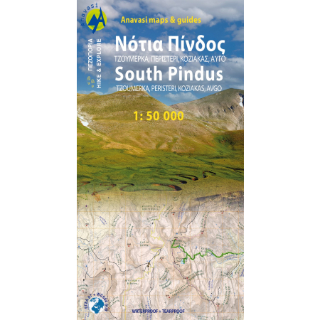
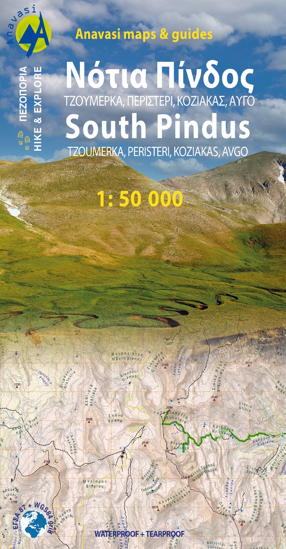
Ο πεζοπορικός χάρτης Νότια Πίνδος [3.2/4.2] Περιστέρι – Κακαρδίτσα -Τζουμέρκα – Κόζιακας – Αυγό – Τριγγία καλύπτει μια τεράστια συμπαγή ορεινή περιοχή που εκτείνεται ανάμεσα στο πέρασμα της Κατάρας (και τη νέα Εγνατία) και τις βόρειες παρυφές των Αγράφων. Περιλαμβάνει δεκάδες γνωστά βουνά που έχει επικρατήσει να ονομάζονται συλλογικά Νότια Πίνδος. Είναι επίσης γνωστά και ως βουνά του Ασπροποτάμου, από τον θρυλικό και πολύπαθο Ασπροπόταμο (τον Αχελώο δηλαδή) που διατρέχει την καρδιά της περιοχής αυτής μέσα απο τοπία απίστευτης αγριάδας. Στο ήδη πλούσιο αρχείο των μονοπατιών των προηγούμενων εκδόσεων προστέθηκαν πολλές νέες διαδρομές και ένα ολόκληρο βουνό, η Κοκκινόλακκα με νέα μονοπάτια που πολύ πρόσφατα διανοίχθηκαν και σηματοδοτήθηκαν. Ανάλογη είναι και η επικαιροποίηση του οδικού δικτύου. Ο χάρτης είναι τυπωμένος σε συνθετικό χαρτί Polyart το οποίο είναι τέλεια αδιάβροχο και ανθεκτικό στη χρήση και είναι τοποθετημένος σε χαρτονένιο φολντεράκι στο οποίο θα βρείτε πληροφορίες για τις αναβάσεις στις κυριότερες κορυφές της περιοχής του χάρτη.
ISBN:
978-960-9412-186
Έτος έκδοσης 2022
Κλίμακα 1:50.000
Hiking map of South Pindos, Tzoumerka, Peristeri, Koziakas, Avgo in a scale of 1:50.000
The hiking map of Southern Pindus [3.2/4.2] Peristeri – Kakarditsa – Tzoumerka – Koziakas – Avgo – Tringia. It covers a huge mountainous area that extends between the pass of Katara (and the new Egnatia highway) and the northern edge of Agrafa massif. Includes dozens of famous mountain peaks collectively called Southern Pindos. It is also known as the mountains of Aspropotamos by the legendary Aspropotamos (Acheloos river) that runs through the heart of this region through landscapes of incredible wildness. Several new paths have been added since the previous editions as well an entire mountain, Kokkinolakkas with new trails recently opened and marked . The road network has been also updated. The map is printed on synthetic paper Polyart which is perfectly waterproof and durable in use and is placed in cardboard folder where you will find information on ascents to the major peaks in the region of the map.
| Scale | 1:50.000 |
|---|
Only logged in customers who have purchased this product may leave a review.
![ΖΗΡΙΑ ΚΥΛΛΗΝΗ [8.31]](https://www.klaoudatos-skishop.gr/wp-content/uploads/2021/02/ZIRIA23-945x1811w-450x450.jpg "ΖΗΡΙΑ ΚΥΛΛΗΝΗ [8.31]")
![ΖΗΡΙΑ ΚΥΛΛΗΝΗ [8.31]](https://www.klaoudatos-skishop.gr/wp-content/uploads/2021/02/8.31-945x1811w-450x450.jpg "ΖΗΡΙΑ ΚΥΛΛΗΝΗ [8.31]")
![ΠΑΡΝΩΝΑΣ [8.7]](https://www.klaoudatos-skishop.gr/wp-content/uploads/2021/04/Parnonas-002-945x1811-1-450x450.jpg "ΠΑΡΝΩΝΑΣ [8.7]")
![ΠΑΡΝΩΝΑΣ [8.7]](https://www.klaoudatos-skishop.gr/wp-content/uploads/2021/04/8.7-945x1811w-450x450.jpg "ΠΑΡΝΩΝΑΣ [8.7]")


![ΓΚΙΩΝΑ ΒΑΡΔΟΥΣΙΑ [2.31]](https://www.klaoudatos-skishop.gr/wp-content/uploads/2022/02/GIONA_VARDOUSIA-945x1811-1-450x450.jpg "ΓΚΙΩΝΑ ΒΑΡΔΟΥΣΙΑ [2.31]")
![ΓΚΙΩΝΑ ΒΑΡΔΟΥΣΙΑ [2.31]](https://www.klaoudatos-skishop.gr/wp-content/uploads/2022/02/2.31-945x1811w-450x450.jpg "ΓΚΙΩΝΑ ΒΑΡΔΟΥΣΙΑ [2.31]")
![ΜΑΙΝΑΛΟ - ΑΡΤΕΜΙΣΙΟ [8.5]](https://www.klaoudatos-skishop.gr/wp-content/uploads/2022/02/menalo_exofylo2020-945x1811w-450x450.jpg "ΜΑΙΝΑΛΟ - ΑΡΤΕΜΙΣΙΟ [8.5]")
![ΟΛΥΜΠΟΣ [6.11]](https://www.klaoudatos-skishop.gr/wp-content/uploads/2021/04/olympus_2023-1-945x1811w-450x450.jpg "ΟΛΥΜΠΟΣ [6.11]")
![ΟΛΥΜΠΟΣ [6.11]](https://www.klaoudatos-skishop.gr/wp-content/uploads/2022/02/6.11-945x1811w-450x450.jpg "ΟΛΥΜΠΟΣ [6.11]")
![ΖΑΚΡΟΣ - ΒΑΪ - ΣΗΤΕΙΑ [11.16]](https://www.klaoudatos-skishop.gr/wp-content/uploads/2022/02/zakros-945x1811-1-450x450.jpg "ΖΑΚΡΟΣ - ΒΑΪ - ΣΗΤΕΙΑ [11.16]")
![ΖΑΚΡΟΣ - ΒΑΪ - ΣΗΤΕΙΑ [11.16]](https://www.klaoudatos-skishop.gr/wp-content/uploads/2022/02/11.16-945x1811w-450x450.jpg "ΖΑΚΡΟΣ - ΒΑΪ - ΣΗΤΕΙΑ [11.16]")
![ΖΑΓΟΡΙ • ΒΑΛΙΑ ΚΑΛΝΤΑ • ΜΕΤΣΟΒΟ [3.1/6.4]](https://www.klaoudatos-skishop.gr/wp-content/uploads/2023/05/zagori_2023-1-1-945x1811w-450x450.jpg "ΖΑΓΟΡΙ • ΒΑΛΙΑ ΚΑΛΝΤΑ • ΜΕΤΣΟΒΟ [3.1/6.4]")
![ΖΑΓΟΡΙ • ΒΑΛΙΑ ΚΑΛΝΤΑ • ΜΕΤΣΟΒΟ [3.1/6.4]](https://www.klaoudatos-skishop.gr/wp-content/uploads/2022/02/Zagori_sample1-945x1811w-450x450.jpg "ΖΑΓΟΡΙ • ΒΑΛΙΑ ΚΑΛΝΤΑ • ΜΕΤΣΟΒΟ [3.1/6.4]")
![ΠΕΝΤΕΛΗ [1.3]](https://www.klaoudatos-skishop.gr/wp-content/uploads/2022/02/penteli-945x1811-1-450x450.jpg "ΠΕΝΤΕΛΗ [1.3]")
![ΜΕΣΣΗΝΙΑ [17]](https://www.klaoudatos-skishop.gr/wp-content/uploads/2022/02/MESINIA-945x1811-1-450x450.jpg "ΜΕΣΣΗΝΙΑ [17]")
![ΜΕΣΣΗΝΙΑ [17]](https://www.klaoudatos-skishop.gr/wp-content/uploads/2022/02/17-945x1811w-450x450.jpg "ΜΕΣΣΗΝΙΑ [17]")
![KALIMNOS [10.32]](https://www.klaoudatos-skishop.gr/wp-content/uploads/2022/02/KALYMNOS20-945x1811-1-450x450.jpg "KALIMNOS [10.32]")
![KALIMNOS [10.32]](https://www.klaoudatos-skishop.gr/wp-content/uploads/2022/02/Kalymnos_sample-945x1811w-450x450.jpg "KALIMNOS [10.32]")
![ΠΑΡΝΗΘΑ [1.1]](https://www.klaoudatos-skishop.gr/wp-content/uploads/2022/02/parnitha-945x1811-1-450x450.jpg "ΠΑΡΝΗΘΑ [1.1]")
Reviews
There are no reviews yet.